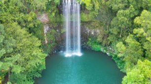
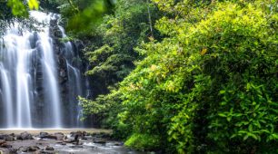
Zillie Falls is one of the quiet treasures of the Atherton Tablelands. Tucked beneath a canopy of ancient rainforest, the waterfall slips gracefully over volcanic rock into the forest below, often wrapped in mist and birdsong. Unlike some of the region’s larger waterfalls, Zillie Falls invites you to slow down, take in the scenery, and appreciate the peaceful beauty that surrounds it. It is a place that rewards those who pause, listen, and simply enjoy being in nature.
Why Visit Zillie Falls
Zillie Falls occupies a particular and beloved place on the Atherton Tablelands waterfall circuit — the second of the three falls on the Millaa Millaa loop, and the one that offers the most intimate and unexpected encounter with the landscape. While Millaa Millaa Falls greets you with drama and Ellinjaa rewards you with width, Zillie is where the water slips into its own private world.
The falls drop through a narrow, mossy channel carved into the dark volcanic basalt, twisting and falling in a series of cascades that end in a small, enclosed pool surrounded by the rich growth of the rainforest. The water moves with a quieter energy here, less the grand theatre of a plunge pool waterfall and more the intricate, personal beauty of a stream that has found its own particular route through the rock over thousands of years.
The short walk from the car park to Zillie Falls passes through beautiful rainforest, and the falls themselves are reached within a few minutes. The pool beneath the falls is smaller than at Millaa Millaa, and the enclosed nature of the site gives it a feeling of privacy and discovery that makes it particularly special. It is a place for sitting with, rather than photographing and moving on.
Zillie is best visited as part of the full Millaa Millaa Waterfall Circuit, along with Millaa Millaa Falls and Ellinjaa Falls, it completes a trio of experiences that each reveal the Tablelands’ waterfall landscape from a genuinely different angle, and together make for one of the finest half-day drives in Australia.


The Walk to Zillie Falls
The access to Zillie Falls is brief and rewarding, a short downhill walk of approximately 300 metres from the Palmerston Highway leads to a spectacular lookout directly above the falls. There is no swimming at Zillie Falls; the geology here is sheer and dramatic, with the creek dropping suddenly over a vertical rock face into a deep pool below the viewing platform. But the visual experience more than compensates: the falls are framed perfectly from the lookout, the mist from the cascade creates a constant gentle coolness, and the surrounding vegetation is lush and tropical in every direction. Zillie Falls is often the first stop on the Waterfall Circuit, setting the tone for the extraordinary natural beauty of the Millaa Millaa district.
Zillie Falls in Context
Zillie Falls exists within a landscape shaped by the volcanic history of the Atherton Tablelands. The basaltic soils of the Tablelands, among the most fertile in Australia, support both the extraordinary rainforest vegetation and the agricultural richness that makes this region famous for its dairy, coffee, tropical fruits and macadamia nuts. The creek systems that create the waterfalls run through this volcanic landscape, cutting into ancient lava flows and creating the dramatic drop profiles that give the Tablelands falls their distinctive character. Understanding this geological context deepens the experience of visiting a site like Zillie Falls, it is not merely beautiful; it is a window into 20 million years of Earth’s transformation.
A Hot Getaways destination. Where Care is Our Compass.
Travel Kindly
At Hot Getaways, care is our compass — and a little kindness makes every journey better. When you visit Cairns, we gently ask you to:
- Protect the reef — wear reef-safe sunscreen and never touch or stand on the coral.
- Respect the wildlife — admire the birds, turtles and rainforest creatures from a distance, and take your rubbish home with you.
- Support local — choosing local operators, cafés and guides helps this beautiful place thrive.
- Honour Country — we travel on the traditional lands and sea Country of Australia’s First Peoples, with gratitude and respect to the Traditional Custodians past and present.
- Be kind to each other — a smile, a little patience and a helping hand make the day lovelier for everyone.
Small acts of care add up to something wonderful. Thank you for travelling kindly.
Honest Suitability: Is Zillie Falls Right For You?
We would rather help you choose well than persuade you to go. Here is our honest assessment.
| Visitor | Our honest view | Why |
|---|---|---|
| Visitors doing the Waterfall Circuit | Yes | Zillie is one of the three falls named on the 17 kilometre circuit, alongside Millaa Millaa and Ellinjaa. |
| Visitors who want a viewpoint rather than a swim | Yes | Zillie is a fall you look at from above rather than one you casually wade into. |
| Visitors with limited mobility | Not verified | Zillie Falls does not appear among the parks managed by Queensland Parks and Wildlife Service, so the responsible authority is Tablelands Regional Council. We have not been able to verify an accessibility statement from the council, and we will not estimate one. A tourism listing is not a land manager statement, so we no longer rely on it here. Checked 3 August 2026. |
| Swimmers | Millaa Millaa is the better choice | The regional tourism body specifically describes Millaa Millaa as a swimming spot; it does not describe Zillie that way. |
Time-Aware and Season-Aware Planning
- Fifteen to twenty minutes is enough for the lookout.
- Half a day for the full circuit from Millaa Millaa township.
- Season: Rainfall here is strongly seasonal. Bureau of Meteorology long-term averages for Cairns Aero (station 031011, 83 years of record) are 404.8 mm in January, 437.5 mm in February and 422.1 mm in March, against just 26.5 mm in August, with an annual average of 2,025.5 mm. Source: Bureau of Meteorology climate statistics, Cairns Aero.
Verified Safety Information
Safety comes before everything else on this page. Every point below is drawn from an official source, and we link to those sources so you can check the current position yourself.
- Queensland Parks and Wildlife Service, which manages these sites, states the position plainly: rivers, creeks and lakes in Queensland’s parks and forests may contain hidden dangers, are not patrolled by lifesavers, and are not the same as a swimming pool — you enter the water at your own risk. Read and follow the on-site signs, never dive or jump into any waterway because the water may be shallow or hold submerged objects, and stay out of the water during and after heavy rain, when creeks can rise quickly and run with strong currents. Source: Water safety, Queensland Parks and Wildlife Service.
- Never dive or jump in. Water depth in a natural pool changes after every flood and submerged rock is not visible from above.
- Queensland Government advice is unambiguous: within the natural range of the estuarine crocodile, which runs from around Gladstone north to the Torres Strait, no waterway can be considered crocodile free. Being Crocwise starts with three steps — keep out of the water, stay more than five metres back from the water’s edge, and keep a sturdy object between yourself and the water. Source: Be Crocwise top tips, Queensland Government.
- Crocodiles are highly mobile, particularly after heavy rain and flooding, and can travel hundreds of kilometres. Queensland Government also states that crocodile interactions can occur at any time of the year, so seasonal reasoning is not a substitute for reading the signage in front of you.
- This is cassowary country. Queensland Government advice is to never approach an adult cassowary, never approach a chick or get between a chick and its father, and never feed a cassowary — feeding is illegal, dangerous, and has resulted in cassowary deaths. Give them space and observe from a distance. Source: Southern cassowary, Queensland Government.
- Check Queensland park alerts and warnings for the Tropical North Queensland region before you leave home, together with current weather and road conditions.
Queensland Parks and Wildlife Service puts it plainly: parks and forests are wild places with hidden dangers for the unwary visitor. Before you leave home, check Queensland park alerts and warnings for the Tropical North Queensland region, along with current weather and road conditions, and pay close attention to warning signs when you arrive.
Every source above was checked and found current on 3 August 2026. Conditions, track access and closures change constantly. Queensland Parks alerts are the current source, and ranger signage on site overrides everything, including this page.
Local Knowledge
The points below are local knowledge and editorial judgement rather than operational facts. They are the things we would tell a friend. Conditions change, so treat them as a starting point and always follow official signage and advice.
- Zillie is the one people rush because it sits between two more famous falls. Give it five more minutes than you planned — the view down onto the top of the drop is the point.
- Mid-morning light tends to be harsh here. Early or late is kinder.
- Take the circuit in one direction and do not double back. The loop is short enough that patience costs nothing.
Helping Look After This Place
Part of the pleasure of a place like this is knowing it will still be here, just as beautiful, for the people who come after you. A few small choices make a real difference.
- Take everything out that you brought in, including fruit peel and tissues, which do not break down as quickly as people expect in the rainforest.
- Stay on the formed tracks. It protects fragile root systems and stops new informal paths forming, and it is also the single simplest way to stay safe.
- Give wildlife room and resist the urge to feed anything. Queensland Government advice is that feeding cassowaries is illegal, dangerous and has resulted in cassowary deaths.
- Support the small local businesses you pass. A coffee in a village bakery or an entry fee at a family-run attraction is what keeps these communities able to look after the places you have come to see.
- Sunscreen, insect repellent and soap all end up in the water when you swim. Rinsing off before you get in, and swimming without them where you can, is a small kindness to a small creek.
- The Wet Tropics Management Authority acknowledges Rainforest Aboriginal Peoples as the Traditional Custodians of the Wet Tropics. Where a site has a traditional name or story, using it is a quiet way of recognising a connection that long predates tourism.
Common Questions About Zillie Falls
Is Zillie Falls on the Waterfall Circuit?
Yes. Tourism Tropical North Queensland names Millaa Millaa, Zillie and Ellinjaa as the three falls on the 17 kilometre Tablelands Waterfall Circuit.
Is Zillie Falls accessible?
We have not been able to verify an accessibility statement from the responsible authority. Zillie Falls does not appear among the parks managed by Queensland Parks and Wildlife Service, so the land manager is Tablelands Regional Council. Until the council publishes accessibility information we will not estimate path surfaces, gradients or distances, and we no longer rely on a tourism listing for this. If precise accessibility matters for your visit, contact the council before you travel. Checked 3 August 2026.
Can you swim at Zillie Falls?
We have not found an official source that describes Zillie Falls as a swimming site, and we will not imply one. Tourism Tropical North Queensland describes Millaa Millaa Falls, on the same circuit, as a great swimming spot. Follow the signage at whichever site you visit.
Where To Go Next
If this one is not quite right for your day, these are the closest alternatives.
- Millaa Millaa Falls — The swimming fall on the same loop.
- Ellinjaa Falls — The third circuit fall.
- All Waterfalls Near Cairns — Compare every waterfall in the region on one page, including which ones are officially listed as accessible.
- Swimming Holes Near Cairns — If a swim matters more than the drop.
- Rainforest and Waterfalls — The wider decision hub, including guided options and rainforest walks.
- Atherton Tablelands — Towns, produce, crater lakes and the cooler country above Cairns.
- The Waterfall Circuit Drive — The classic Tablelands waterfall drive, turn by turn.